
Huge thanks to Lynnette Cen, GIS Education Specialist and ACC Alum, for sharing this project!
Texas General Land Office publishes first three-dimensional GIS Educational Map
Over the last several years, the Texas General Land Office’s (GLO) Archives and Records Division has embarked on an ambitious project to use geographic information system (GIS) tools to create a series of GIS Educational Maps specifically suited for education and research. The aim has been to simplify imagery found on historic maps and to convey new or traditionally overlooked information in a way that is approachable for younger learners and seasoned Texas history enthusiasts alike.
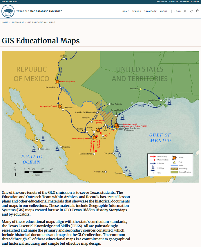
Click here to view the GIS Educational Maps showcase page.
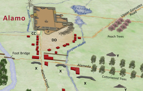
The latest GIS Education Map published, Aerial View of San Antonio de Béxar and Alamo Fortifications, 1836 (2026), is the GLO’s first three-dimensional (3D) map produced using GIS technology. The term “aerial view” refers to any view from a great height, often from an airplane either looking down or sideways from a window. In the nineteenth century, maps of this type came to be known as “birds-eye” views. Sitting at just under 3,000 feet and at an approximately thirty-degree angle, this map uses an oblique projection to show each building as 3D.
Lynnette Cen and Dominic Romo, Aerial View of San Antonio de Béxar and Alamo Fortifications, 1836, Austin, TX: 2026, Map #97522, TGLO.
To create this look, staff first constructed a two-dimensional (2D) map depicting the town using flat polygons for buildings. Lines in 2D represent the San Antonio River, San Pedro Creek, roads, and acequias (irrigation ditches). The basemap features a watercolor style and parchment texture from Esri, a GIS mapping software. Adding height to each polygon completed the map’s conversion to 3D.
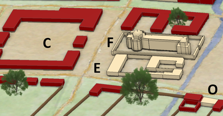

GLO staff used an oblique projection to create 3D polygons such as these buildings in the aerial view map. Notice the different shapes used to create San Fernando Church (F). A 3D model of the Alamo created by Pape-Dawson Engineers is featured in the upper right corner of the map. Details surrounding the Alamo include a pecan tree in the top left corner and abatis in the bottom right.
Containing an unprecedented level of detail for a GLO-produced GIS Educational Map, this is the largest scale – one inch to two hundred feet – used to this point. This facilitated an incredible amount of detail, including the Alamo’s artillery pieces, images of horses at the Potrero, and fencing and white oak trees known to the area. A dead tree in the northwest corner of the Alamo mimics a pecan tree during the winter. An abatis (defense made of felled trees) appears in the Alamo’s southeast corner. The map also locates batteries from the Texians’ Siege of Béxar and the Battle of the Alamo. The estimated sites of the Alamo funeral pyres appear on either side of the Alameda (cottonwood grove) roadway as reported by Béxar alcalde Francisco Antonio Ruiz. This thoroughly researched, intricate recreation of San Antonio de Béxar provides viewers a useful new tool to help understand the conditions surrounding the siege and fall of the Alamo.
To access this map online, as well as the rest of the GLO’s growing collection of in-house GIS Educational Maps, click here.